Reference to the ‘magic’ figure of 33 states forming the Mthwakazi federal has been a common theme in the last few articles and attempts to define them made, but the whole conversation has been a wordy abstraction with the public’s creative minds left to imagine the states configurations. There has been little visuals shared to give the electorate an idea of what a Mthwakazi state might look like. Using maps (Figures 1 – 3), this article will give greater visual insight into how we have arrived into the number of states we propose.
For illustrative purposes, refer to Figures 1 – 3 which show the current electoral districts; we have turned the referred 26 electoral districts (13 each in Matabeleland North and South) into states while the Bulawayo province’s 12 electoral districts have been joined together to form a single state. 6 states derive from the Midlands giving us a tally of 33 states that form a Mthwakazi federal state.
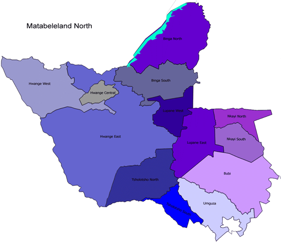
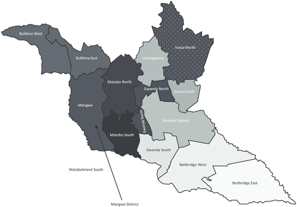
This hypothetical figure of 33 states is an essential figure that helps us explore and illustrate the application of the various political options at our disposal on how a Mthwakazi state will function. We however, will not lose sensitivities of our diverse people and would at this point again make it clear that the final state configurations should be decided upon by the residents.
While we would like to entrust our legislators with making the right decisions on the states’ configurations, we are not blind to the fact legislators represent us the people, not just geographical territories. We elect them to listen to our causes, carry out honest, impartial debates and research for answers and new knowledge of doing things and above all to consult us when they make new laws or changes to existing ones.
So as long as Mthwakazi is a representative government, and our legislators are the instruments of government elected directly by us and directly representative of the people, it must be an expectation that we – the people – will determine the final configurations of our states; the right to freely instruct our leaders of what our preferences would be will remain the bedrock of the political system. Whether we want some current states split or joined together will be our decision to be made in a referendum, if need be.
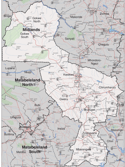
When it comes to the midlands (light grey shade), it would be important to note some areas (e.g. Chirumhanzu) are part of Mashonaland, but it should be easy to identify and confirm which areas are Mthwakazi territory and which ones are not. The process however, goes beyond physical boundaries, we must determine if the residents on those geographical areas identify themselves as Mthwakazi people. If not, how will that case be handled humanely without causing unnecessary social and economic harm to the people?
We have an opportunity to create a hopeful over a fearful nation; we have a chance to align with light over darkness, to marvel over shining stars not be petrified by darkness. But for all that to be possible, our people need to understand that settlement in a geographic area will not of itself translate into our control of the area; we need to seize control of our territorial economic and political independence, and that calls for the broadening of our minds so that dreams are quickly translated into our lived reality.
Finally, we are reminded that to be who we are, we have a duty to take the initiative and rebuild the Mthwakazi nation and reclaim the architectural design of our nation; engage in infrastructural design to redesign the geographic area we occupy to be reflective of our culture. Any delay risks allowing opportunity for someone else to convert more time than us in the territory and we will find ourselves servant or second class citizens in the Mthwakazi territory and whoever it is who converted more time than us in the space will become our king and rule over us.

One response to “The states of the Mthwakazi federal”
[…] is the name given to the traditional nation-state made up of modern-day Matabeleland and parts of present day Midlands region and covers territory to the southwest of modern-day state of Zimbabwe. The social and culturally […]
LikeLike